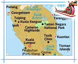
Location: 3°8?N - 101°42?E
Altitude: 21.95 meter
Kuala Lumpur, the largest city of Malaysia, stretches in an estimated area of 243.65 sq km. On the west coast of Peninsular Malaysia, this federal territory is actually an enclave in the state of Selangor. The capital's geography is characterized by a huge basin called Klang Valley, which emerged by grouping of the adjacent towns (Petaling Jaya, Subang Jaya, Shah Alam, Klang, and Port Klang).
KL is surrounded by the Titiwangsa Mountains in the east, some minor ranges in the north and the south, and the Strait of Malacca in the west. Located at the convergence of Klang and Gombak rivers, Kuala Lumpur is perched
 at an elevation of 21.95 m above sea level. The
municipality is just about 35 kms from the coast; it locates at the
centre of the recent and extensive transportation network of the
Peninsula. Its strategic location on the west coast, which has more of
wider flat land, has added to the rapid development of the city.
at an elevation of 21.95 m above sea level. The
municipality is just about 35 kms from the coast; it locates at the
centre of the recent and extensive transportation network of the
Peninsula. Its strategic location on the west coast, which has more of
wider flat land, has added to the rapid development of the city.Owing to specific activity or attraction, Kuala Lumpur can be segregated into the following areas: City Center, Golden Triangle, Tuanku Abdul Rahman, Brickfields, Bangsar and Midvalley, Damansara and Hartamas, Ampang, Northern Suburbs, and Southern Suburbs. Mostly encircled by forests and hills, Kuala Lumpur is the only city in the world to have a million-year-old primary forest within the conurbation.


